The Association for the Improvement and Adornment
of San Francisco was formed on the fifteenth of January, 1904, by the following
gentlemen: Messrs. James D. Phelan, E. R. Taylor, William Greer Harrison,
E. W. Hopkins, Henry J. Crocker, Leon Sloss, Charles E. Green, Allan Polloki
Thomas M'Caleb, R. J. Taussig, A. H. Payson, Walter S. Martin, L. M. King,
Fred Patek, John Partridge, N. B. Greensfelder, T. Cary Friedlander, William
G. Irwin, W. A. Bissell, Herbert E. Law, Willis E. Davis, E. 0. McCormick,
P. N. Lilienthal, Frank J. Symmes, J. W. Byrne and F. W. Dohrmann.
These few gentlemen comprised the original membership,
and out of their number the following officers were elected: James D. Phelan,
president; William G. Irwin, vice-president; Leon Sloss, treasurer; and
with them on the board of directors were Herbert E. Law, William Greer
Harrison, Thomas Magee, Allan Pollok, R. B. Hale and T. C. Friedlander.-
Thomas M'Caleb acted as the secretary. Today there is a membership of over
four hundred, and to the board of directors R. J. Taussig, Bruce Porter,
Captain R.H. Fletcher and P. N. Lilienthal have since been added. The association
is incorporated.
The main objects of the association are to promote
in every practical way the beautifying of the streets, public buildings,
parks, squares and places of San Francisco; to bring to the attention of
the officials and the people of the city the best methods for instituting
artistic municipal betterments; to stimulate the sentiment of civic pride
in the improvement and care of private property; to suggest quasi-public
enterprises, and, in short, to make San Francisco a more agreeable city
in which to live. Finally, to discover and indicate the ways and means
by which all these results may be best attained.
Shortly after the organization was perfected the
board of directors adopted a programme of procedure, which might be considered
a practical guide for the work the association had in view. First, in order
to insure united action on the part of auxiliary societies upon all matters
affecting the common interests, an advisory council has been formed. It
consists of the board of directors of the association, together with two
delegates from auxiliary societies, such as the Out-Door Art League and
the California Chapter of the American Institute of Architects.
As a preliminary step to the association's purposes,
D. H. Burnham, the eminent architect, was invited to direct and execute
a practical and comprehensive plan for the improvement and adornment of
the city, similar to the plans prepared under his direction for Washington,
Cleveland, Chicago and Manila.
Mr. Burnham accepted the task, giving his services
gratuitously, the association paying the expenses incidental to the work
and the salaries of his subordinates. At his request a bungalow was built
on a spur of Twin Peaks, Willis Polk being the architect. At this point
of vantage, selected to command the panorama of the city and to permit
uninterrupted study, the work was begun on September 20, 1904.
THE PROBLEM
It is proposed to make a comprehensive plan of San Francisco, based
upon the present streets, parks and other public places and grounds, which
shall interfere as little as possible with the rectangular street system
of the city.
SCOPE
The scope of this report is general. It covers such subjects as the
direction and length of all the proposed streets, parkways and boulevards;
the size and location of proposed Places, round points and playgrounds;
the size, location and broad treatment of proposed parks; and closes with
general recommendations. It is not the province of a report of this kind
to indicate the exact details very closely.
It is not to be supposed that all the work
indicated can or ought to be carried out at once, or even in the near future.
A plan beautiful and comprehensive enough for San Francisco can only be
executed by degrees, as the growth of the community demands and as its
financial ability allows.
The plan is so devised that the execution
of each part will contribute to the final result. That result will combine
convenience and beauty in the greatest possible degree.
A scheme of parks, streets and public grounds
for a city, in order to be at once comprehensive and practical, should
take into account the public purse of today and embrace those things that
can be immediately carried into effect, but should in no wise limit itself
to these. It should be designed not only for the present, but for all time
to come.
While prudence holds up a warning finger,
we must not forget what San Francisco has become in fifty years and what
it is still further destined to become. Population and wealth are rapidly
increasing, culture is advancing. The city looks toward a sure future wherein
it will possess in inhabitants and money many times what it has now. It
follows that we must not found the scheme on what the city is, so much
as on what it is to be. We must remember that a meager plan will fall short
of perfect achievement, while a great one will yield large results, even
if it is never fully realized.
Our purpose, therefore, must be to stop at no line
within the limits of practicability. Our scope must embrace the possibilities
of development of the next fifty years.
A city plan must ever deal mainly with the direction
and width of its streets. The streets of San Francisco are laid out at
right angles and with little regard for grades and other physical difficulties.
It may be impossible to overcome all the embarrassments arising from this
condition, but certainly we can lessen them materially.
The difficulty may largely be conquered by girdling
the city with a boulevard--a method of facilitating communication which
is by no means new. To this embracing highway all streets lead, and access
may be had from any one of them to another lying in a distant section by
going out to this engirdling boulevard and following it until the street
sought opens into it. This method of communication, enabling one to avoid
the congested districts, is a delightful one, although not so direct and
useful as the diagonal streets within the city, which will be particularly
described hereafter.
This boulevard should be a broad, dignified and
continuous driveway skirting the water edge and passing completely around
the city. There are several streets and parkways already in use that may
become parts of it; the others should be undertaken at an early date, because
there is no work to be done on the thoroughfares of San Francisco that
will yield greater immediate and lasting results.
To open all the diagonal streets proposed in the
plan will be the work of a generation, as was the case in Paris, but once
the outer encircling driveway is established, these diagonals will follow,
affording direct and satisfactory access to it from the various centers.
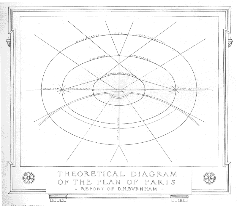
A study of the cities of the Old World develops the
fact that the finest examples--Paris, Berlin, Vienna, Moscow and London--consist
of a number of concentric rings separated by boulevards. The smallest of
these rings, enclosing the Civic Center--that portion of the city which
plays the most important part in civic life--is located at or near the
geographical center.
The accompanying diagram,
No. 1, shows at a glance this type of city.
THE PERIMETER OF DISTRIBUTION
From this inner circuit boulevard, run diagonal arteries to every section
of the city and far into the surrounding country. Intersecting in the first
place the periphery, or outer wall, they traverse in succession the variouscircuit
boulevards, which represent in themselves the successive stages of the
city's growth, and finally reach the center or group of centers which,
in a measure, they traverse to connect with one another and form continuous
arteries from one side of the city to the other.*
It is on this study that the proposed system of
circulation for a larger and greater San Francisco is based. Experience
shows that the radial arteries should be many, and that the inner circuit
from which they start should be small in radius. This circuit has been
named the perimeter of distribution. It surrounds the center which the
radial arteries traverse (which may be termed the center of circulation),
and in conjunction with this it forms the Civic Center.
RELATION OF THE CIVIC CENTER TO THE FINANCIAL AND MANUFACTURING
DISTRICTS
The Civic Center thus described is one of administration, education,
amusement and shopping of the finer order. There are two other sections
of the city which may be regarded as centers--the financial district, in
the vicinity of California and Sansome streets, and the manufacturing district,
south of Market street. These are closely related to each other and to
the Civic Center. They communicate with the Civic Center, the former by
means of Market street, the latter by the Panhandle extension south of
Market; and with each other by means of Sansome street extended south of
Market.
San Francisco can possess the innermost and outermost
boulevards mentioned above. The former is the perimeter of distribution;
the latter, the periphery, can easily be developed as a boulevard. But
the intermediary circuit boulevards, if carried in a concentric form, would
be impracticable, owing to the hills. They are therefore replaced, as suggested
in the plan, by a series of contour roads circumscribing the hills, connected
with each other on the level ground by arteries (for the most part parkways),
with which they form an irregular chain concentric to the inner perimeter,
as complete as the topography will allow.
ELEMENTS OF THE CITY--ADMINISTRATIVE AND EDUCATIONAL
The city may be divided into the following elements: lst--Administrative
and Educational; 2nd--Economical; 3rd--Residential.
lst-This is the real being of the city proper; all
else should contribute to its honor and maintenance. In its national character
it guarantees the city's relation to the country and in its civic character
to the citizens.
This center comprises,
Firstly: Those structures devoted to the interests
of matters administrative, of national, municipal, judicial and educational
character, grouped in proper relation to one another:
City Hall.
Court of justice.
Custom House.
Appraisers'
Building.
State Building.
U.S. Government
Building and Postoffice.
Secondly: Those structures, public or private, of monumental character and of great civic interest relating to matters literary, musical, esthetic, expositional, professional or religious:
ELEMENTS OF THE CITY--ECONOMICAL
2nd-The economical element of the city involves two considerations--
(a) Distribution; (b) Finance.
(a) Distribution: this includes international and
internal commerce and comprises:
WATER-FRONT
San Francisco possesses about ten miles of water-front. As compared
with other large cities this is very little, and there is no doubt that
it will be inadequate to the needs of the future. Although there
is nothing to check its expansion down the eastern bayshore to the county
line and beyond, its value decreases as it becomes more remote from the
center of the city. It is therefore thought necessary to develop as much
as possible that part of the water-front extending from the ferries to
Hunter's Point. A system of docks, inclosed by the sea wall, as shown on
the plan, would triple or even quadruple the extent of wharfage. The increased
quantities of cargo would be stored in a system of extensive warehouses,
thus concentrating shipping as much as possible. It is not the aim here
to solve the problem of property interests or to lay down in detail the
scheme suggested, but merely to indicate the direction in which it should
be studied. The question of circulation to and from the city has been considered
and will explain itself.
The Outer Boulevard follows the sea wall. It is
necessary to connect it with that section of the city lying near it, inhabited
by people of moderate means. Where the main arteries from this section
intersect it, there should be piers for public recreation, a yacht and
boat harbor and vast bathing places, both inclosed and open-air. People
will seek the Outer Boulevard, and will find refreshment and benefit from
the water frontage. The design of the roadway arranges for this without
interfering with its use for shipping.
SUBWAYS
Rapid underground transit solves the problem of moving large crowds
from one center to another in a manner that no surface system
can accomplish, and inasmuch as surface traction renders boulevards less
agreeable and less serviceable for other traffic, it is suggested that
the main diagonal arteries proposed on the plan should be provided with
an underground service of cars traversing the center by means of a loop
described under the central plaza (the necessary excavations made simultaneously
with the construction of the new arteries). There should be another loop
line under the artery described as perimeter of distribution. At least
two lines should be constructed at right angles to one another as the growth
of the population warrants; the most pressin- need at the present is that
of Market street. The economy in time of covering the greater part of a
journey across town, by rapid transit, completin- it by transfer with a
surface car, is self evident. The problem in its simple form, on level
ground or slight grades, has been dealt with successfully in other cities
and needs no comment. Where, however. the steeper grades and contour roadways
extending around the hills are encountered, it is suggested that the subway
might be built as a gallery, below the roadway, opening to the view, or
the car line built on the slope slightly below the roadway.
The wholesale quarter represents:
ELEMENTS OF THE CITY--RESIDENTIAL
3rd-Residential--(a) Urban, (b) Suburban, (c) Country.
(a) The residential districts develop as necessity
demands; the pioneers or small householders retiring in many districts
before the advance of better improvements. The most desirable district
should be studied in anticipation for the right size of block, size of
street and general disposition, preservation of view points, park areas,
etc., in order that once settled into place the best districts may be valuable
to all and initial errors will not have to be rectified at great cost.
A great charm might be lent to certain quarters, particularly the less
expensive and flatter sections of the city, by the elimination of some
of the streets in the monotonous system of blocks, and substitution of
a chain of park-like squares, formed in a measure by the unused or misused
back-yard areas.
The isolated square of the Old World, unless maintained
by wealthy residents, is a quiet, almost desolate spot, seldom feeling
the throb of life. The chain is suggested to obviate this, and induce a
current of life to flow agreeably from end to end, to the exclusion of
unnecessary vehicles, thus leaving the main traffic to the intermediate
streets. In case the houses front on the squares a new system might be
evolved. Thus the cars and service might be thrown on the streets (narrowed),
whilst the Park chains would become public avenues of beautiful planting,
in which one could walk with great comfort, and where children could play,
free from danger of traffic. Such a system would provide well for children
who seldom know any life except that upon the streets of the city and would
be the natural approach or connecting link between the larger parks and
the playgrounds.
BOROUGH CENTERS
As the city grows such places as Colma, Ocean View and Baden, which
will eventually become borough centers, should reserve large commons, on
which may face the civic buildings.
THEORY OF THE HILLS
Theoretically the hills are a series of planes diminishing in their
ascent. Considering only the more important hills, this indicates the character
which should be given to roads climbing them, for each hill or succession
of hills should be circumscribed at its base, as already described, by
a circuit road. As the higher levels are reached in unbuilt tracts the
level circuits or contour roads become easy of accomplishment. They should
be repeated at various heights and should be connected by easy inclines.
Places of interest should be emphasized by terraces with appropriate approaches.
ALONG THE WATER-FRONT--NORTH
Taking the foot of Market as a starting point, the Outer Boulevard
runs north along East street, traversing the docks and passing around the
base of Telegraph Hill. The direction of this part follows the line of
the water-front; where it passes close to the wharves it cannot take the
same level as the street, but must be elevated. It is therefore proposed
to carry it over the warehouses, its roadway forming their roofs. This
will give the city an extensive line of fire-proof storage property and
will enhance the value of neighboring realty. This elevated part of the
boulevard may be beautifully treated. There should be enough space to allow
a foot or two of earth for planting. It will then be an ideal place for
a ride or a walk, the passer-by looking down on the shipping below, and
when he tires of watching the activities and listening to the voices of
the men engaged in the work of the port, he may note the changing aspects
of the sea and study the effects of sunshine and shadow on islands and
mountains seen through the masts of the ships. This treatment will lend
delightful variety to a drive on the boulevard, and will add a special
charm to the life of the city.
THE PRESIDIO
At the intersection of the boulevard with Montgomery avenue it is proposed
to rebuild Fishermen's Wharf and to construct a yacht harbor, a recreation
pier and a ferry slip. After skirting this quarter of boats and nets, of
fishermen and markets, the boulevardrounds Fort Mason and emerges on a
straightaway run along Lewis street to the Presidio, in full view of the
northern reaches of the bay, always covered by sails and steam craft, with
Mount Tamalpais in the background across the reaches of the water. Entering
the Presidio reservation and sweeping around the parade ground, as shown
on the plan, the boulevard climbs the slope to McDowell avenue. Looking
east from this point the whole bay may be seen, and rounding Fort Point,
the Golden Gate comes broadly into view. Here also the military terrace
comes into view, forming another delightful incident of the journey.
POINT LOBOS
Here it sweeps down across Lobos creek, reaching the headlands. It
will follow their contour to Point Lobos and thence down to a broad terrace
and shelter opposite the Seal Rocks. On these headlands it may either parallel
the new electric road, though at a lower level, or rise along the crest
of the cliff to a level of 300 feet and then gradually descend again until
it reaches the terrace.
From the concourse in the Presidio to this terrace
the view of the Golden Gate is uninterrupted, and stretches far away to
the north, the west and the east.
ALONG THE OCEAN SHORE
Running south, the boulevard follows the Cliff House road until it
reaches the Great Highway, and then, bordered on the east by the Park and
on the west by the ocean, it carries in a straight line to the northwestern
section of the Laguna de la Merced country.
The special treatment requisite for this ocean section
of the boulevard will be based on the plans of Mr. McLaren. It is proposed
that the boulevard be built at a certain elevation above the present highway,
which should eventually be raised to the same level. The normal height
of the sand-dunes, according to observations made, dictates the level of
this roadway.
Entering the Merced country, the boulevard skirts
the western shore of the lake, and crossing the county line, traverses
a wide, sheltered valley to Colma. This will probably be a borough center.
From Colma to a point near Baden station (the 11-mile
house), the boulevard corresponds with the San Mateo highway. Then it either
runs between South San Francisco and the outer hills of San Bruno Mountain
or crosses the beautiful valley situated between the main line of hills
and the southern spur, reaching the bay at Sierra Point.
THE WATER-FRONT--SOUTH
At Sierra Point the boulevard turns northward once more, having now
almost girdled the peninsula. Skirting Visitacion Bay at the water edge
and crossing the hills, it joins Railroad avenue, crosses Islais creek
and traverses Kentucky street to the water-front. Then, following East
street to the foot of Market, which was the point of starting, the outer
boulevard completes its circuit of about thirty miles.
THE SEA WALL
That portion of the boulevard which strikes inland from Sierra Point,
across Railroad avenue and Kentucky street, will eventually be replaced
by a driveway following the line of the Sea Wall. Thus far the Sea Wall
has been planned only to the county line. That is merely an arbitrary stopping-place,
and without doubt the increase in population and business of this important
section of the city will necessitate the extension of the Sea Wall into
San Mateo County, at least as far as Sierra Point, which it will reach
in almost a direct line. When this comes to pass, the present plan for
the southern part of the boulevard will be modified. Instead of pursuing
the Railroad avenue and Kentucky street route to the water-front, it will
be carried north from Sierra Point around Hunter's Point and so reach the
foot of Market street.
CONTINUATION OF THE GREAT HIGHWAY
Where the boulevard enters the Lake Merced country, after traversing
the complete length of the Great Highway, a new driveway, a continuation
of the Highway, should begin. This should be built along the ocean side
of the hills, and should extend south-ward as far as possible. In some
places it should pass near the water, in others higher up, as is the case
with those celebrated driveways of the Riviera which skirt the Mediterranean
from Nice, through Ville Franche and Monte Carlo, to Mentone and beyond.
Both roads, that is to say, this ocean highway and
the inner boulevard, should wind in and out, following easy contours and
grades. This treatment will insure great charm; at some points the Pacific
will be disclosed; at others the beautiful Laguna country, with its gem-like
water and its boundaries of high hills. One has but to recall the high
driveways beside the sea at Monterey and Bar Harbor to realize the superb
natural scenery that such a road will easily open up to San Francisco.
DIAGONAL ARTERIES
The rectangular plan of the streets of San Francisco has rendered inter-communication
difficult, more especially where the grades are very steep, as is often
the case. To overcome this difficulty of moving from center to center,
diagonal streetsshould be cut in many places, and certain streets should
be widened, extended and regraded.
It is not within the scope of this report to lay
out the streets and public centers with exactitude, but rather to indicate
their general size and locations, leaving the details to those public servants
who, from time to time, will have charge of the actual execution of parts
of the plan. Of course, nothing is here proposed that is not entirely feasible.
First in importance is the extension of the Panhandle
to the center of the city.
The problem of rendering most accessible the large
parks already in existence has been carefully studied and its solution
has been found to be the extension of the Panhandle directly to Market
street. Any other working-out of the problem presents greater difficulties
and would give more round-
a out, and consequently less dignified results.
PANHANDLE EXTENSION [image
I7]
The Panhandle extension, involving a whole block in a direct line with
the existing Panhandle, is bounded by Oak and Fell streets, whose grades,
as working roadways, are to be left almost intact. But to obtain a good
driving grade between these streets certain changes must be made; the grade
raised in places between Gough and Laguna and Scott and Broderick streets,
and a deep cut in the hill made between Laguna and Pierce streets.
The grade, rising gently from Van Ness avenue, with
a maximum of 5 per cent, reaches its summit at Steiner street and thence
sweeps gently down and up to join the existing Panhandle at Baker street.
A certain sympathy is thus obtained between the drive and the natural contour
of the land. Lined on either side by a double row of black acacias, the
drive is relieved from monotony by a planting of shrubs and flowers, while
masses of larger trees inclose the vista with an interesting skyline.
The blocks from Van Ness avenue to Octavia street,
where the grade is practically level, will, no doubt, become a commercial
district. Here the Panhandle is reduced to a boulevard 150 feet in width.
Beyond Octavia street, as the grade increases, the
necessity for cross traffic and entrances diminishes, and the planting
becomes gradually richer until the maximum of interest is reached at the
highest grade by the addition of terraces, with hanging gardens of flowers.
From the summit the drive dips almost imperceptibly and with increased
picturesqueness of planting reaches the point of transition, a public Place
with central motif. From this one emerges into the sylvan beauty of the
original Phnhandle. This round point is also the junction for the auxiliary
Panhandle from Market and Dolores streets and other boulevards to be described
hereafter.
West of Octavia street, only Fillmore and Devisadero
streets are carried through. There the necessity for cross traffic is imperative.
It is suggested that Devisadero be carried under the drive and Fillmore
over the drive. The objection to bridging the drive is met in a measure
by the necessity or desirability of having a crowning feature on the hill.
The viaduct can be made interesting architecturally and hung with flowers
and vines, forming a rialto to the great driveway.
For purposes of approach and general harmony of
effect a number of changes in the way of filling and cutting on the actual
grades of Fell and Oak streets are recommended, as shown on the plan. These,
however, are not necessary to the immediate execution of the Panhandle
project.
THE CENTER OF THE CITY
The Panhandle is to meet Market street at Van Ness avenue, and the
crossing of these three great thoroughfares naturally indicates the center
of the city. Accordingly, this junction is to be a spacious concourse,
from which wide thoroughfares will radiate in all directions.
At this junction there should be constructed a semi-circular
Place having for its center the intersection of the axis of the
Panhandle and Van Ness avenue.
PERIMETER OF DISTRIBUTION
The thoroughfares radiating in all directions from this Place
will intersect at various points the circular boulevard described in the
Theory of the Civic Center as the "perimeter of distribution." At each
of these points will be constructed a public Place of the form and
size indicated on the plan.
This perimeter of distribution will consist of a
number of arteries connecting the various Places. They run as follows:
Starting from the western facade of the City Hall
at Larkin and Fulton streets, up Fulton as far as Gough; thence by means
of a diagonal to Octavia street at the Panhandle extension; thence down
Octavia to Market;* from Market and Octavia streets, by means of a diagonal
cut, to Fourteenth and Capp streets; thence down Fourteenth to Eleventh
and Bryant streets; thence by means of a diagonal to Eighth and Harrison;
and finally up Eighth street to City Hall Square.
MARKET STREET
The increasing congestion of lower Market street indicates the necessity
for widening this thoroughfare. It may be accomplished gradually, as done
in the Old World, by establishing new frontage lines, all future improvements
replacing old structure ' s to conform to these lines. The completion
of this widening will thus be measured in time by the economic life of
the most substantial existing structures.
TREATMENT OF EIGHTH STREET
Eighth street should be widened from Market to the extension of the
Panhandle. Where it crosses the latter there should be a small public Place.
From this Place Eighth street should be widened and made a continuous
parkwayto Hooper street. It commands for its whole length a view
of the City Hall dome. It may then be used as a playground for the neighborhood
on both sides. At Hooper street there will be a round point, inclosed on
the east by a public athletic ground.
From this round point a parkway one block wide should
extend south to Nineteenth street, which will be the northern boundary
of the proposed park on Potrero Heights.
From this round point also Sixteenth street
should be widened and extended to the Outer Boulevard. Potrero avenue should
extend from Division street north to its intersection with Eighth street
and south to Twenty-sixth street.
From the intersection of Eighth and Harrison streets
a wide diagonal avenue should be made, passing through the public Place
in front of the proposed Union Depot and continuing on to Twenty-second
street, as shown.
DIAGONAL FROM MARKET STREET TO THE MISSION
A wide diagonal should extend from the foot of Market street to the
intersection of Harrison and Sixth streets. This roadway would then carry
the heavy drayage from the northern shipping and wholesale district to
the Mission and beyond, and would thus relieve the growing congestion on
Market street. Harrison street from Sixth to Eighth should be widened.
In order, further, to facilitate communication between
the North and South of Market street, it is proposed to extend across this
artery Grant avenue, Mason and Leavenworth streets, as shown.
A diagonal should extend from the Ferry to
the intersection of Sansome and Pacific streets. Pacific street should
be widened to the width of Pacific avenue.
Sansome street should extend across Market
street, as shown, to Howard street. It should be widened from Market street
to Filbert, where a diagonal should continue it to East street north.
Montgomery avenue should be widened and extended
from Washington street to Market, passing around a monumental bourse, bank
or office building which should occupy the center of the block bounded
by Sansome, Sacramento, Battery and California streets. Montgomery avenue
should extend south of Market street, in the line of Fremont, to meet the
diagonal proposed for that neighborhood.
At the foot of Montgomery avenue, where it
meets the Outer Boulevard, there should be a yacht harbor and a recreation
pier, as shown. (These are mentioned in connection with the Outer Boulevard.)
From Montgomery avenue and Broadway a diagonal,
almost level, should run to Bay street at Hyde, thence west on Bay street
to Larkin, thence to the crossing of Lombard street and Van Ness avenue,
where it will meet the diagonal described below, which runs to Broadway.
APPROACH TO THE CALIFORNIA-STREET HILL
A diagonal from the corner of Golden Gate and Van Ness avenues should
run to the intersection of Geary and Leavenworth streets, and from that
point to Bush street on easy grades. From Bush and Powell streets it should
run on a curve to Sacramento and Powell streets,crossing California street
at an elevation by means of a bridge. (The treatment of this bridge should
be architectural, in order that it may form a crowning feature of the view
from lower California street.)
Running to the intersection of Taylor and
Washington streets, the roadway should lead by way of Taylor street south
to the Heights of California Hill. Its continuation from Taylor and Washington
streets connects with Pacific street at Jones, from which the northern
heights of Russian Hill are served, and encircling the hill to the northeast,
reaches the junction of Van Ness avenue and Lombard street, already mentioned.
There should be a winding road starting from
the corner of Broadway and Fillmore streets and passing through the southeastern
part of the Presidio to the Main Entrance, as shown.
Point Lobos avenue, from the corner of Hamilton
square to Sutro Heights, should be a boulevard.
A diagonal should run from Geary and Leavenworth
streets to Broadway at Octavia, intersecting Van Ness avenue at Sacramento.
CHANGES OF GRADE
A change of grade is recommended for Golden Gate avenue from Hyde street
to Taylor. Likewise for Leavenworth street from Turk to McAllister street,
and for Jones street from Turk to McAllister.
CONNECTION OF DEVISADERO STREET WITH CORBETT AVENUE
It is proposed to connect Devisadero street, which is one of
the important cross-town thoroughfares, with Corbett avenue
by means of a diagonal running from Haight street to Duboce avenue and
Castro street, and thence around the hill in the form of a crescent.
This diagonal will connect the north shore with the Lake Merced district
by passing around Twin Peaks.
From the round point of the Panhandle at Baker St.
six roads branch out.
THOROUGHFARES RADIATING FROM THE PANHANDLE AT BAKER STREET
lst. This road should sweep southwest on a rising grade to meet Ashbury
street at Frederick street, and continue thence to the narrow terrace located
at the southwest corner of the Amphitheater.
2nd. A diagonal to a round point located at the
southeast angle of Golden Gate Park, from which one road leads southeast
to the north entrance of the Amphitheater and continues up to the terrace,
mentioned above, by way of Clayton street. It runs to the Great Highway,
traversing the whole Sunset district.
3rd. The diagonal between the Baker street round
point and the junction of Market and Dolores streets, which has already
been mentioned. This is of great importance. It will afford an outlet to
the Park and Presidio for the whole Mission district, and has long been
contemplated and demanded by the residents in that section of the city.
4th. A diagonal to the corner of Hayes and Baker
streets. This is to continue up Baker to Turk street, thence in a crescent
through Calvary cemetery to a round point at Presidio and Point Lobos avenues.
From this round point it will sweep, practically on a level grade, to Alta
plaza, thence down Jackson street, over two blocks to Broadway, along Broadway
to Octavia street, and thence by a diagonal to the corner of Lombard street
and Van Ness avenue.
Everything possible should be done to widen
Lombard street and make it a boulevard from Van Ness avenue to the Presidio.
5th. The diagonal to the Presidio. It traverses
two cemeteries and brings up at the First avenue entrance of the military
reservation. This is a most important road, as it is a continuation to
the Presidio of the diagonal running south from the Panhandle to the Mission
district.
6th. A diagonal to the northeast corner of Golden
Gate Park, and thence to the intersection of Point Lobos avenue and the
new parkway that connects Golden Gate Park with the Presidio.
The streets bordering Golden Gate Park on the north
and south should both be widened to boulevards.
From the southwest corner of Jefferson square
a diagonal leads to the southeast corner of Hamilton square, thence to
the corner of Presidio and Point Lobos avenues, running on Geary street
widened.
The parkway between Thirteenth and Fourteenth
avenues is already definitely planned. From its center other avenues radiate,
as shown. All are necessary in order to afford reasonably direct routes
of communication and to concentrate traffic at certain points.
DIAGONAL ARTERIES IN THE SUNSET DISTRICT
West of Twin Peaks lies the Sunset District. In its center there should
be a public square from which four avenues radiate:
lst. To Seventh avenue, joining the diagonal
from the Panhandle at Baker street, by way of H street widened.
2nd. To the southwest corner of Golden Gate
Park.
3rd. To the northwest corner of the Lake Merced
property.
4th. To the public square now owned by the
city and bounded by Twenty-sixth, Twenty-eighth, V and W streets.
PARKWAY THROUGH SUNSET DISTRICT
East of the above mentioned square there should be another public square
fronting the ocean, as shown. These two squares should be connected
by a parkway. This treatment promises unusual beauty and will greatly enhance
the pleasure of living in that vicinity.
This parkway should be carried east to intersect
with the, parkland about Twin Peaks. An entrance at Nineteenth avenue will
preserve the view of the whole sweep of the ocean north and south, which
would otherwise be lost by the gradual building up of this district.
From the outer end of this parkway two diagonals
should run, one northeast, the other southeast, as shown. Where they cross
other diagonals there should be round points.
Nineteenth avenue should be widened from Golden
Gate Park to the northern boundary of the Lake Merced district.
PARKWAY BETWEEN TWENTY-THIRD AND ALVARADO STREETS
A cross-boulevard or parkway should be made between Twenty-third
and Alvarado streets.This parkway should extend from Bellevue street to
the proposed park on Potrero Heights and thence to the Outer Boulevard
at Kentucky street. This would necessitate the cutting through of certain
blocks of Alvarado street now non-existent. The choice of this space for
a parkway is governed by an interesting consideration, viz: its axis corresponds
with the axis of Twin Peaks, and it would therefore yield the most beautiful
view of them. But the parkway has other advantages. It would afford direct
communication between the park on Potrero Heights and the superb park spaces
at the west end, and at the same time it would furnish wide breathing spaces
and playgrounds for the numerous residents along its entire length.
Probably no other expenditure of money will bring
surer returns in health, happiness and consequent good citizenship than
the sum required to construct this parkway.
PRINCIPAL ARTERIES OF THE MISSION
This parkway will intersect a large public square into which
all the principal streets of this part of the city will open. These
streets are six in number, as follows:
lst. The three-fold thoroughfare, formed by Mission,
Capp and Howard streets, which will extend from this square north to Van
Ness avenue prolonged and which has been described already. It is intended
to exclude wheel traffic from Capp street, to arcade it on both sides,
and to face upon it fine shops that will extend through to Mission street
on one side and to Howard on the other. It will also be widened and planted
as a parkway and will become a market-place continuing throughout the Mission.
2nd. The diagonal from the Railway Place
described above.
3rd. A wide diagonal from Dolores and Eighteenth
streets to this square.
4th. A diagonal running from this square to the
intersection of Potrero avenue and Twenty-sixth street, and thence to a
round point at the intersection of the County Road and Eve street. From
this round point a parkway and a boulevard should start. The parkway, similar
to the cross parkway described above, would run between Ninth and Tenth
avenues and would penetrate to Railroad avenue. The boulevard would run
to the intersection of Charter Oak avenue and Islais creek channel, Charter
Oak avenue being extended south to the intersection of Railroad avenue
and Wilde street.
MISSION BOULEVARD
5th. A great artery, which might well be called Mission Boulevard,
running southwest from this square to San Mateo County. This should be
two hundred and ten feet wide and should continue to Islais creek. At its
intersection with the latter a large Place should be built, from
which many roads will diverge.
In developing a Theory of the City mention was made
of the fact that San Francisco, on account of its peninsular situation,
has but one outlet by land-its southern one. Eventually there will be three
highways connecting San Francisco by this route with San Mateo County.
One will drain the eastern section. (By way of Railroad
avenue and Charter Oak avenue completed and extended from Potrero avenue
and Twenty-sixth street to the round point at Wilde and Fortieth avenue
south.)
Another will tap the western section by way of the
Lake Merced country.
The third and most important will run from the heart
of the city through the Mission. This is the Mission Boulevard, into which
the first two will flow south of San Bruno Mountain.
Four highways have already been referred to as opening
into the large public square to be established on the main axis of Twin
Peaks where Mission, Howard, Twenty-third and Alvarado streets intersect.
Into this, as has been indicated, will flow the new routes to the ferries,
to Golden Gate Park and the Presidio, to Hunter's Point and South San Francisco
and Mission and Howard streets.
At this square a fifth highway, Mission Boulevard,
also begins. Two hundred and ten feet in width it sweeps, at a grade of
from one and one half to two and one third per cent, to the saddle in the
hills between Bernal Heights and the Fairmount Tract, where a cut of 35
feet is made. This is the City Gateway, the natural entrance to the city.
From this point the road drops gently at a grade of two and one fifth per
cent to Islais creek, where a fill of 15 feet is proposed, and rises at
one per cent grade to a level stretch at an altitude of 160 feet and then
continues to rise at a grade of two and one third per cent to the county
line. At its intersection with Foote street an alternative route is suggested,
departing from the Mission roadbed and running to the intersection of the
Southern Pacific railroad with Worcester avenue, thus economizing in ascent
and descent nearly 100 feet.
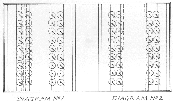
This boulevard should consist, as shown in the accompanying diagram, of five divisions. Three of these are roadways, comprising the principal roadway in the center and two smaller ones on the outsides. The central roadway is separated from the smaller one on either side by a planted, space. These, therefore, are the five divisions of the boulevard, and their order, reading on the diagram from left to right, is: smaller roadway, planted space, central roadway, planted space, and smaller roadway. Both planted spaces will include gravel walks, and, in addition, there will be in one, a double track service for cars, and in the other a bridle-path. These latter sections will be contiguous to the main roadway, as shown on diagram No. 1, or the boulevard may be arranged as shown on diagram No. 2, in which the cars are placed on either side of the central roadway-making one planted space a bridle-path and the other a promenade.
ISLAIS CREEK PLACE
At the crossing of Islais creek it is proposed to create a public
Place into which will lead other arteries, viz:
Silver avenue (deflected).
Ocean avenue (extended).
Crescent avenue (extended).
Rock Cañon roadway (proposed).
Visitacion Bay roadway (proposed).
To obviate the disadvantage of cutting across Islais
creek it is proposed that an upper and a lower parkway be made by filling
in the creek to the west of the Place and there creating a small
lake. From this the water will flow in cascades to another small lake east
of the Place, and thus there will be an upper and a lower waterway,
as at the Bois de Boulogne in Paris. On the Place a terrace, overlooking
the lower parkway which winds to the bay on the east, will afford an interesting
view.
From the round point at Islais creek three roads
are shown, east of Mission Boulevard, diverging to the south and through
the valleys in the hills to the Outer Boulevard. These all lead through
beautiful scenery and are desirable both from practical and esthetic standpoints.
6th. The extension due south from the square of
Mission, Capp and Howard streets to Bernal Heights, as shown. These roads
already exist.
It has been suggested that the present right-of-way
of the Southern Pacific Company in this territory may some day be traversed
by an electric road. It has been suggested that when this comes about the
right-of-way should be widened and that a traffic road for teaming should
be added. This is practicable, but would necessitate considerable grading
where the tracks are now carried on trestles.
West of Mission Boulevard two other roads are shown.
One passes through Glen Park, ascends Rock Cafion to join the Corbett road,
runs across the valley of the San Miguel to Laguna Honda and there joins
Seventh avenue, which is widened as far as H street.
The other crosses Islais creek. It is the extension
of Ocean avenue, which runs through the Merced Lake Valley to the Great
Ocean Highway.
University street should be widened as shown and
its extension carried across Islais creek on a viaduct to meet Holly street
widened, thus forming an outlet to the city by way of the Mission Boulevard.
From the round point at the junction of Berkshire
and Arlington streets (Fairmount Tract) a road should rise on a gentle
grade on Arlington street to Mateo street, cross thence to the intersection
of Miguel and Palmer streets, and, using Palmer as far as Harper street,
should rise to the terrace or outlook above, as shown.
TRAFFIC TUNNEL THROUGH ASHBURY HEIGHTS
In addition to the graded roads crossing Ashbury Heights, which connect
the Mission with the northwestern portion of the city, it is advisable
that there be a tunnel for car traffic. This as shown on the
plan, should enter the hill at Clara avenue north of Seventeenth street
and emerge at Parnassus avenue and Clayton street.
This tunnel would greatly facilitate communication
between the Sunset district and the city proper. It should be placed on
as direct a line as possible between them and should enter the hill at
a low level, so that there may be a clear distinction between it and the
roads over the hill. By placing it at the lowest possible level the advantage
of directness would be gained and the site of the proposed Amphitheater
would not be interfered with.
The diagonals shown on the plans which connect the
Outer Boulevard with parallel boulevards running through the Potrero and
South San Francisco need no special explanation.
In general it may be set down that the proposed
roads, when taken in connection with those already existing, will open
the city on all sides through arteries crossing it from side to side in
the most direct manner. While the scheme aims at an ideal arrangement of
thoroughfares, it is careful also to take into account the many steep grades
and other conditions that can never be entirely overcome. It must be carried
out little by little, as the needs of the city demand and as the growth
of the commonwealth furnishes the means of accomplishment.
HILLSIDE STREETS
As a rule the streets that run into the hills should end where grades
become too steep for easy carriage roads. In the unbuilt, outlying districts,
where street systems already exist the proposed treatment will vary according
to particular conditions. Where the grades are reasonable the present street
system will remain: where the grades are so steep as to make the streets
inaccessible the system will be obliterated and replaced by contour roads,
which should be so placed as to form junctions with available streets already
existing. In certain cases these contour roads would become continuous.
This would be effected by repeating them at several levels and connecting
them by means of easy-graded inclined planes.
On the southeastern slope of the hill, below Buena
Vista Park, a study of the existing streets has been made with a view to
illustrating the advantages of continuous streets encircling a hill. Thi
' s has been done by the suppression of some streets and addition of others
contributing to this end on easier grades.
THEIR GENERAL TREATMENT
The various forms lent to the public concourses by conditions of existing
and proposed streets, of grades, etc., render a typical description impossible.
They will vary from actual park spaces to simple work-ways for vehicles.
However,their general treatment, as to dimensions, paving, crossings and
planting, is shown on the map.
Where public buildings are concerned uniformity
of cornice height and regularity of design should be observed and when
great private buildings surround these concourses they should have a height
limit. (See general recommendations.)
A special study should be made of each concourse,
so that the best results may be obtained by making the designs of private
structures contribute to the general effect. In many cases the vistas of
streets converging on these squares might be closed by appropriate architectural
motives. This applies particularly to those concourses through which the
main arteries of the city
flow.
CIVIC CENTER [map
I4, aerial
view I5]
Of these concourses the most important architecturally are the Civic
Center and its public Places.
The architecture of the Civic Center must be vigorous
if it is to hold its own and dominate the exaggerated skyline of its surroundings.The
climate of San Francisco admits of a bold style of architecture, for the
atmosphere softens profiles and silhouettes. The column should be freely
used as the governing motif.
CITY HALL SQUARE
It is proposed to enlarge City Hall Square in the form of a semi-circle.
In order to accomplish this from 20 to 25 feet of the property surrounding
the Square and about the same amount along City Hall avenue and along McAllister
street from Larkin toLeavenworth street should be purchased. On this space
there should be constructed an arcade or colonnade of regular cornice height
termnated by pavilions flanking City Hall Square at Market street. This
treatment would, in some measure, extend the architectural effect of the
Civic Center around the City Hall and impose a sense of order in its vicinity.
On gore lots facing public squares, where practicable,
a treatment might be adopted similar to the well known Fontaine St. Michel
of Paris. This suggestion applies to such a corner as the gore of Market
and Geary streets, where more open space is required to relieve traffic
congestion.
The important part which adequate park spaces may be made to play in
civic life is now generally recognized and need not be dwelt on here.
The small parks and playgrounds should be distributed
uniformly throughout the city, the exact sites being chosen with a view
to emphasizing their importance.
THEIR TREATMENT
The treatment of the small parks should be in accordance with one general
ideal, some variety, of course, being allowed in the arrangement of details.
They should present an agreeable appearance to passersby and plenty of
shade and pleasantsurroundings to those who resort to them.
The playgrounds will admit of more individual treatment.
Their distribution will be governed by the density of the population in
various sections of the city. They should provide uniformly for the wants
of all the people, men, women and children. The proposed parkways south
of Market street will be auxiliary to them and will provide ample playgrounds
for the very little children.
THE DISTRICT PLAYGROUNDS OF CHICAGO
This subject of district playgrounds has been very fully treated by
Henry G. Foreman, President of the South Park Commissioners of Chicago,
in an article entitled "Chicago's New Park Service," contributed to the
Century Magazine. We cannot better illustrate the scope these playgrounds
should have than by quoting extensively from his article. What he says
of Chicago applies with nearly equal force to San Francisco:
"The Commissioners," he says, "had started out to
provide simple parks; but the conditions showed that such places, to be
serviceable in a city where seventy per cent of the people live in contracted
quarters, must be more than breathing-spaces with grass, flowers, trees,
and perhaps a pond and a fountain. They must afford gymnasia, libraries,
baths, refectories, clubrooms, and halls for meetings and theatricals.
They must be useful day and evening, summer and winter. The public must
receive a continuous and ample return upon its investment--daily dividends
in happiness, health and progress.
"Thus the idea of the field-house, or neighborhood-center
building, had its birth.
"Every field-house contains a gymnasium for women
and girls, provided with apparatus, shower-bath, plunge-bath, and lockers.
In another part of the building is a like gymnasium for men and boys.
"Clubrooms, where meetings of athletic clubs, sewing
guilds, and other organizations are held, and an assembly hall, are also
found under the roof of each field-house. These halls are used for district
meetings assembled for any good purposes, except political or sectarian.
It is expected that these public meetings will replace the old neighborhood
stagnation with neighborhood patriotism and unity of purpose and development.
"But the field-house does not afford all the service
in the new parks. Outside of it is a large swimming-pool, provided with
dressing rooms for men and women.
"In addition to the swimming-pool, each park has
a shallow wading-pool for children and a sand-pit where they may play.
Each also has swings, giant strides, and other athletic apparatus.
"In the parks are running tracks, and all have outdoor
gymnasia, connected with the indoor gymnasia, for supplemental service
in summer.
"The park building is placed near the promenade
and the concert grove, the outdoor gymnasia for both men and women, and
the natatorium.
"The large feature is the assembly hall, shared
by men, women, and children as a shelter, and arranged for lectures and
entertainments. The ceiling is high, showing open timbers. A stage is provided,
and, in close communication, a refectory, a retiring-room for women, and
a smoking-room for men.
"Flanking this hall are the wings accommodating
the social and athletic functions for men and women respectively. From
the wings the hall is separated by entrance vestibules, controlled by attendants'
offices and opening into the locker-room; the public toilets, and the staircases
leading to a second story. Here are arranged the club-rooms, library, and
class-rooms.
"The out-of-door swimming-pool is screened by the
main building and by vine-covered pergolas, is arranged with a southern
exposure, and is inclosed by walls on the north, thus gathering and reflecting
the sun's rays. This raises the temperature and prolongs the bathing season.
Flowering shrubs, vines, and lawns enrich the pool enclosure, and stretches
of sand invite the swimmers to enjoy sun-baths.
"The dressing booths, in extended rows, are removed
from the main building and are controlled by a special office. From the
booths the swimmer passes to the pool through a shower bath, where there
are soap and brushes. Adjoining the booths is the laundry, with the heating
service. There also is a hair-drying room for women."
The intention is to include in each hilltop park
a playground, arranged, if necessary, in terraces from which a good view
of the city may be had. By thus affording the young appropriate places
for recreation and giving them at the same time a broader outlook a twofold
educational purpose will be served.
In general, the playgrounds should connect with
some one boulevard or parkway, in order that they may be in touch with
one another. In many cases the sites of these proposed parks are being
placed at the junction of two or more of these large arteries.
It is important that an individual character be
given to each park. This might be furthered by the use of a dominant family
or variety in the scheme of planting. They might even be named from the
flower or tree that predominates in them. Such a plan would have the effect
of stimulating the interest of residents in the park located in their neighborhood.
The accompanying drawing shows a typical arrangement
for small playgrounds. It is suggested as the plan for the proposed park
north of Washington square. Advantage is taken of the sloping ground to
give the additional charm of a terraced treatment--the small children being
placed at a higher level than the ball field.
The many hills within the city limits may be grouped under the following heads:
CONTOUR ROADWAYS
In the general treatment proposed a line of base has been chosen varying
in height with each hill, but in the main horizontal, repeated at various
levels on the higher hills. This takes the form of a level contour roadway
accented at places of interest by terraces with approaches as shown on
the plan. The advantage of this basic line both practically and esthetically
is very great. It should be continuous and approached, as before described,
by inclined roadways.
It is proposed in general to acquire for public
purpose those slopes of the hills too steep for building; and where contour
roads run through resident districts to reserve from 50 to 100 feet in
addition on the lower side, in order to retain in some degree the outlook
over the city.
The hilltops south of Golden Gate Park should be
preserved intact as far as possible.
It has been suggested that the actual roadway of
those streets too steep for driving be narrowed by the reservation of planting
spaces. This treatment would redeem in a measure the furrowed effect of
the city skyline.
It will be well to crown the summits of the hilly
streets with one or two markers relieved against the sky or with a central
suspended lamp.
All streets ending abruptly at a hill should be
planted out, making an entrance to the park above. The latter would be
attained by winding pathways passing through successive terraces and carrying
the eye to the summit.
This hill is of historic importance and could only
be removed at a great cost. It is recommended to leave it intact as to
mass, to reform the street system gradually by terracing and planting streets
impassable to traffic and, in general, to make the hill more habitable.
The principal approaches are as shown on the plan; they lead to a contour
road enclosing a park proposed for the summit as described under Parks.
The roadway encircling Russian Hill has been described
already. It is important that the streets abutting on this drive above
and below should be terraced and planted in order that the drive may become
as much as possible a parkway. The outlooks at street intersections will
have a great charm. A terrace might terminate the vista of Lombard street
from the Presidio.
The general recommendations made for steep streets
on Russian Hill apply to the north slope of Pacific Heights. They apply
in particular to the proposed approach from Van Ness avenue and Lombard
street and its continuation at about 200 feet contour level from Broadway
and Fillmore streets. By means of this terraced roadway passing through
the Presidio, access is had on easy grades to the Richmond district at
the First avenue entrance, and to the upper roads of the Presidio.
This should be left intact, the base only planted.
The base line formed by the planting of Calvary cemetery as seen from the
west, should be preserved and extended on the avenues surrounding the base
of the hill.
This hill, already richly planted with cypress trees
and live oaks, forms the northern horn of the crescent of hills encircling
the city. It should be provided with one or more terraces or outlooks commanding
the splendid views in every direction and connected by planted avenues
(as shown) with the Twin Peaks group.
The four approaches to this group from the city are
already mentioned under "Streets, Boulevards and Parkways." They are, first-the
extension of Market street, which will be the northeastern approach; second-Mission
parkway, between Twenty-third and Alvarado streets, the approach from the
cast; third-the contour grade from Islais Park and Mission street, the
south-eastern approach; and fourth-the Panhandle and Ashbury street, which
constitute the northern approach from the Western Addition.
The first is the most important. It is to extend
by grades around Twin Peaks and will sweep down into the Lake Merced valley.
This is the main drive and will be joined at various levels by the other
three.
The approaches by Market street and the Mission
parkway will command the most direct and imposing views of Twin Peaks and
should be marked by terraces leading the eye to the summit. The southeastern
and northern approaches are to be interrupted by terraces, which will be
points of interest commanding a view of the peaks and of the city.
LEVEL CONTOUR DRIVE
Encircling the entire line of the hills there is to be a level contour
drive, 600 feet above sea level, and where feasible on the high crests,
one at 800 feet. These level contour roads will be connected with the various
approaches and with one another by easy grades and will be so arranged
as to leave the peaks unscarred bycuts across the eastern side. They exemplify
the treatment of the hills already described in the Introduction and will
afford most interesting
views of the city, the bay and the ocean.
It is proposed to encircle this hill by a level contour
roadway at an elevation of about 200 feet, approached, as shown on the
plan, from the north, the west, the east, and the south.
On the north, by those streets already existing,
running through the heart of the Mission and united at the base of the
hill in a square bounded by Twenty-sixth, Army, Mission and Howard streets.
A winding roadway climbs the hill from the square, passing through successive
terraces.
On the west, from the hills southeast of Twin Peaks,
by a road crossing Mission Boulevard on a bridge.
On the east, from the Potrero, by a winding roadway
starting from Potrero and Army streets.
On the south by a roadway rising from the terminal
of a viaduct across Islais creek.
The treatment of the base and the streets abutting
on it will be similar to that already described for the other hills.
This hill it is proposed to encircle by a level contour
roadway at an elevation of about 150 feet. This will be approached as described
under "New Streets, Boulevards and Parkways," by gradients and terraces
from the north, east and west. On the south it will be connected by an
avenue with Bernal Heights. Thus it will complete the chain of horizontal
circuit roadways at various levels which is to girdle the entire range
of hills surrounding the city proper and form a base to each hill.
Lying between Islais creek and Visitacion valley
and extending west to the Lake Merced district is a low range of hills.
They are comparatively unbuilt upon. It is therefore suggested that their
street system be modified where the grades are too steep for traffic, the
steeper slopes being planted and a general system of terraces adopted which
would embody all the suggestions made for the hills in other parts of the
city and control future expansion across the county line to the south.
TREATMENT OF UNIVERSITY MOUND AND EXCELSIOR HOMESTEADS HILL
The University Mound and Excelsior Homesteads Hill will exemplify this
treatment. The eastern half of this hill is reserved for park purposes;
the western half will be handled as follows:
It is to have a lower and an upper circuit road.
The lower circuit road, which is at the base of the hill and at an elevation
of about 220 feet, consists in part of existing streets and in part of
diaogonal cuts connecting them. The upper circuit road, at an elevation
of about 400 feet, is entirely new and follows the contours. Within the
boundary of the latter read the street system is obliterated and gives
place to a formal terrace and park treatment, which will make the summit
of the hill a delightful place to live. Between the lower and the upper
circuit roads the street system is modified in the general form of the
theory.
To the east and west of this hill the street system
is left in a great measure intact; on the northern slope it is replaced
by a series of contour roads connecting the east and west. These run from
Japan avenue to Felton street.
The upper and lower circuit roads should start and
end in the park and should be treated as parkways, thus preserving and
accentuating the unity of the hill.
This range of hills should be left intact. More trees
should be planted as a protection to the country on the east and to the
Outer Boulevard.
These are dealt with under "Parks."
The Park Board estimates the present park area at
from 1300 to 1400 acres, including some ground still unimproved. With the
present population of 400,000 this gives an average of 285.7 people for
each acre of park. According to estimates made by Henry G. Foreman of Chicago,
the average for the most important cities of the United States is 206.6
persons for each park acre. So San Francisco is considerably below the
average.
It is evident that with an increasing population
more park area must be provided to meet future needs and bring the ratio
nearer the proper average. The standard for large cities in the United
States is set by Boston, where the average is 42.2 persons per acre.
The present park spaces of large area are grouped
to the west of the city, and the poorer classes of the Mission and Potrero,
who are already distant from them, will be still further removed as these
districts expand toward the south.
Golden Gate Park presents a serious problem for
the future--that of cross circulation from the Sunset to the Richmond district.
Straight cuts north and south should be avoided. Instead diagonals, in
straight or curved lines, should be carried across the Park as far apart
as economy of time in crossing will permit. The diagonal boulevards traversing
the districts north and south of the Park are designed to concentrate the
traffic at certain points of intersection with the park boundaries. It
is from these points that the Park cross roads should start. At each point
of intersection there should be a small Place.
Encircling the city are a number of tracts of land admirably situated for park purposes. Several of these are already public parks and have been mentioned in the foregoing chapter. In order to keep pace with the growth of population, it is proposed to convert the others into parks, thus completing the chain about the entire city.
SELECTION 0F PARK SPACES
In considering what tracts might most wisely be added to the park system
those places have been chosen which have a certain natural beauty, but
are, nevertheless, ill adapted for private occupancy, either from their
steepness, inaccessibilityor difficulties of drainage.
For the most part selection has been made of those
hills whose use as parks will shelter the city from the west by enclosing
it with a girdle of planting. This will start at Buena Vista Park, extend
across the Twin Peaks group and its continuation to the south, over Bernal
Heights and end at Potrero Heights. In case of a great conflagration this
system of parks and connecting parkways would form an effective barrier
ta its spread.
GENERAL TREATMENT OF PARKS
It is essential in a city of such elevations that the parks be studied
for their effect from afar, as each hill affords a view of the others.
It is for this reason that the terraced effect and the horizontal contour
road is recommended.
It is suggested that a consistent type of architecture
of the greatest simplicity be used in the large parks. Buildings, the memorials
of fêtes or expositions, no matter how interesting they may be, have
no real sympathy with a park and are therefore an unrestful influence.
If statuary is placed in the parks it is better
to make formal parterres and all6es for its reception than to scatter it
haphazard.
Although the romantic treatment of parks is admirable,
it should at least be accompanied, in a certain proportion, by a more formal
disposition of tree-planting, which will lend the added charm of contrast
and color. In the smaller parks this amounts to a lesson of order and system,
and its influence on the masses cannot be overestimated.
The striking beauty of the vista in celebrated European
gardens, and in particular in the masterpieces of Le Notre, in France,
is a sufficient argument for its application where conditions are favorable
to its use.
The entrances to parks need not be covered
portals.
The principal parks proposed are:
ITS APPROACHES
There are two approaches to these terraces, both starting from Washington
Square. They meet on the lower terrace at a point bounded by Kearny, Montgomery,
Filbert and Union streets.
The first is a driveway beginning at the northeast
corner of Stockton and Filbert streets. It sweeps around the hill to the
north, developing in its ascent a view, from a terrace facing Chestnut
street between Dupont and Kearny, of the Golden Gate and the northern bay.
The second is a terraced approach on the cast and
west axis of Washington square, between Filbert and Union streets. This
is a parkway and connects the park at the summit of Telegraph Hill with
Washington square.
The contemplated playground north of Washington
square completes the group.
Other approaches, terraced and planted as shown
on the plan, in particular Kearny and Montgomery streets, will afford interesting
vistas up to the summit of the hill.
The precipitous slope to the east should be provided
with winding paths reaching and passing through many minor terraces in
their ascent. A level contour path should be made on this side about the
100-foot line as shown.
The city should acquire, for a bay shore park adjacent
to the Outer Boulevard, the land bounded by Lewis and Laguna streets and
Fort Mason; also that strip of land encircling the Government Reservation
to the east and enclosing the proposed yacht harbor. By so doing it would
be enabled to preserve the beauty of the point and to restrain the encroachment
of any buildings other than club-houses and those of a semi-public character.
In view of the growing importance of the Presidio
(it is now under the command of a brigadier-general), and of its natural
topographical advantages, everything possible should be done, with government
cooperation, to make of it a monument to the United States Army. Already
in a measure a public park, the Presidio may be made more accessible by
cooperation with the military authorities.
Its treatment presents a double aim: so to
arrange the drives and concourses that the public may enjoy the best possible
views of the landscape, and to allow the public to participate in the military
maneuvers.
The approaches from various parts of the city
have already been described. In view, however, of the establishment of
an artillery post on the high ground in the western part of the Presidio,
it is thought that a belt line of cars should be introduced, both for the
convenience of the post and the visiting public. But it should not penetrate
far enough to obtrude on the view from the shore drive.
That part of the Outer Boulevard connecting
the Presidio with Sutro Heights should be built now and the land next to
the beach held, so that its treatment as a whole can be corrected.
There should be places off the road where
people can lounge and enjoy the Golden Gate.
GENERAL TREATMENT
The scheme indicated on the plan aims at suggesting the most appropriate
treatment, not in detail, but in general. It includes the enlargement of
the present parade ground and the location of post headquarters centrally
on its main axis; also the creation of a vast drill ground-the parade and
drill grounds being connected by afore court into which will run the two
main northern approaches.
PARADE GROUND
The parade ground should be inclosed by terraces of slight elevation,
accessible to the public.
DRILL GROUND [image
I13]
The drill ground is inclosed naturally to the south and west by slopes
easily convertible into terraces and grass gradines, from which the public
in large numbers may watch the maneuvers, the bay making a fine background
for the spectacle.
It is proposed also to create a great terrace on
the west commanding the unrivaled view of the Golden Gate.
These points of interest are connected with one
another and with the main entrances by existing and proposed roads. It
is suggested, however, that glades be opened through the forest (where
they would not interfere with the fortifications), forming with the natural
slopes fine vistas from point to point of interest.
PRESIDIO PARKWAY
It is conceded that the parkway between Thirteenth and Fourteenth avenues
will connect with the winding road which now hangs on the south side of
the Presidio hills. But, in addition to this, it should continue in vista
straight to a monumental round point on the Presidio range and thence to
the bay as directly as possible in the form of a glade to the parade ground.
At this monumental round point the winding
road meets the road from the First avenue entrance and united in one avenue
they run directly to the great terrace.
The Thirteenth and Fourteenth avenues parkway, connecting
Golden Gate Park with the Presidio, should be a straight avenue, not a
winding one, because there are already enough winding roadways in the park
and a straightaway swing up and down hill will be more beautiful than a
tortuous road.
At each end of the connecting parkway there should
be a Place.
The abandoned cemetery on the headlands northwest
of the Richmond district should be made a park, as proposed. It should
be studied with regard to the Outer Boulevard at that point and a connection
should be established between it and Sutro Heights. Great importance should
be given to terraces or outlooks to the finest views.
This park, open to the public, should be eventually
acquired by the city. Its main approach will be Point Lobos avenue, which
should be carried directly into the park and terminate in a court. On the
north and south. axis of this court, at the highest point, a Casino should
be placed. It should be as nearly as possible on the axis of the Great
Highway.
From the court or plateau a series of terraces should
be built leading in successive stages to the concourses, replacing the
present Cliff House.
The Cliff House should be condemned, removed and
a concourse providing some slight shelter substituted, thus opening to
the view the sweep of the headlands to the north and the ocean from the
Cliff House road. This road is a link of the Outer Boulevard. It should
be widened, its curves simplified, its grade adjusted and it should run
between the concourse and the terraces, rising in successive steps to the
court in front of the proposed Casino in Sutro Park.
As indicated on the plan, Twin Peaks and the property
lying around it, extending as far as the Lake Merced country, should be
acquired by the city for park purposes. The privilege to use the Merced
property should be obtained and restrictions should be made in regard to
building.
The park areas are planned to include most of the
highest points and those areas least adapted to building. The idea is to
weave park and residence districts into interesting and economic relations;
also to preserve from the encroachments of building the hill-bordered valley
on the northwest and southeast running through the Rancho San Miguel land
to Lake Merced, in order that the vista from the Peaks to the ocean may
be unbroken. It is planned to preserve the beautiful cation or glen to
the south of Twin Peaks and also to maintain, as far as possible, the wooded
background formed by the hills looking south from Golden Gate Park.
This park area of Twin Peaks, which includes the
hills that surround the San Miguel valley and is terminated by Lake Merced,
is a link in the chain of parks girdling the city. The planting (for it
ought partly to be planted), should be carried to a height on the north
and south sides of Twin Peaks and sweep lower across its face as a great
festoon from which Twin Peaks will rise with greater effect as the focal
point of the city.
The forests on the hills enclosing the San
Miguel valley should be cleared through its natural axis, leaving a clear
sweep to lake and ocean. This is a superb vista toward sunset.
A lake, to serve as a
reservoir, as will be described under "Water Supply," should be created
west of the peaks, at the head of this valley, and perhaps the water might
be carried in cascades to Laguna Honda or even to Lake Merced.
From the level contour drives many beautiful
vistas will open. Terraces must be built, the trees cleared away in vista
from them, and a special selection made of plunging views into the valley.
Bordering the lake and in part surrounded
by it, are certain eminences. This spot in the heart of the valley would
be an attractive place for public recreation buildings. But if they were
too large they would disfigure the general beauty of the park.
From crest to crest of these hills might be
cut forest glades, festooning from one to the other. The highest crests
should be left free from trees and crowned with terraces.
FLORAL FESTIVAL
Twin Peaks ought to be not only a public park, but a center for great
public fêtes in which the natural beauties of city and county would
be the chief attraction. Every improvement directed towards this end would
contribute to the growth and
beauty of the city.
West from Twin Peaks would stretch the valley
to the lakes and ocean. Here there would be already the forests of planted
trees, themselves characteristic of California, and in the bed of the valley,
flowing up under the trees, into the glades, from terrace to terrace and
from hill to hill, masses of the most beautiful of California's fruits
and flowers-some as permanent planting, some for f6te purposes and still
others, sheltered in delicate structures, accentuating the natural lay
of the ground by the terraces in which they are placed.
The sheet of water is both attractive and
useful, and contour drives give plunging and intimate views of the whole
composition.
The view to the east will be none the less
striking. By day will be seen the avenues converging to the peaks, the
terraced approaches and the girdle of hilltop parks; by night the chain
of forest glades will be outlined in their undulations from hill to hill
by permanent or temporary illuminations.
AMPHITHEATER [image
I14]
To the north of Twin Peaks lies a natural hollow bounded by Clarendon
and Parnassus avenues, Clayton and Stanyan streets. Here it is proposed
to create an amphitheater, or stadium, of vast proportions. Natural slopes,
which might easily be converted into grass terraces, surround it on three
sides. Its southern side runs to an elevation of 800 feet and commands
not only the field below, but a fine view of the Golden Gate beyond.
This amphitheater would recall by its location the
stadium in the hills at Delphi, which overlooks the Gulf of Corinth, and
the theater of Dionysos, at the foot of the Acropolis, from which the Piraeus
and the Sea of Egina come finely into view.
In it might be held the horse show, polo matches,
football, lacrosse. and other games.
VILLA GROUNDS
The gentler slopes and more sheltered valleys of the Twin Peaks and
the adjoining hills will probably be utilized in time as villa properties.
The proposed level contour roadways will adapt them to this use.
In order to preserve the view, it is recommended that the city acquire
a strip of land on the lower side of all roadways, thus forcina structures
down the slope: or. by ordinances, building within 50 or 100 feet of the
road might be restricted. In order to allow for villa sites it is suggested
that the park space shall not approach nearer than 150 feet of the roads
encircling the main hills, as shown on the plan. This applies particularly
to the 600-foot contour road and the extension of Market street around
Twin Peaks.
THE ACADEMY
The plans for Twin Peaks include a collective center or academy, which
is to be arranged for the accommodation of men in various branches of intellectual
and artistic pursuits. Here they will be grouped for independent study
or collaboration and will enjoy the constant inspiration of ideal surroundings,
an association the city will do well to cultivate.
It will consist of:
First, administrative headquarters, assembly,
reception, lecture and dining halls, together with the necessary services;
and
Second, small structures fitted for special
work or study, provided with living accommodations and connected with the
central group by easy approaches.
These structures might be grouped under the
three heads of letters, science and art. A little open-air theater, after
the ancient Greek model, would form part of this scheme.
The site recommended for this academy is on
the southeast slope of Twin Peaks, as shown.
THE MATERNITY
It is suggested, as shown on the plan, that choice be made of a site
for a Maternity. It is thought that the influence of such an establishment,
in surroundings of the most ideal character, yet not far removed from the
city, would be of great moral value.
THE ATHENÆUM [image
I15]
High in the hills grouped about the Twin Peaks, yet sheltered by them,
it is proposed to establish an Athenæum.
Its natural site is the termination of the great
vista from the hills north of Twin Peaks to the Merced country and the
ocean. The orientation on this axis is a good one, facing neither the prevailing
winds of summer nor winter.
The Athenæum, so called, should receive some
few of the greatest works of art. It would consist of courts, terraces
and colonnaded shelters. These latter should be arranged after the manner
of the great Poecile of the Villa Hadrian. This consists of a wall so built
as to collect the warmth of the sun and afford protection from the wind.
On either side of the wall is a colonnade with a covered promenade where
visitors may walk in the sunshine or the shade without being bothered by
the wind. There should also be protected or colonnaded terraces commanding
the principal views of the city and park land. These, too, might be modeled
on similar terraces in the Villa Hadrian overlooking the Vale of Tempe.
The central court, as shown on the main axis,
is the key to this composition and would be the setting for the principal
monument.
The motive of this monument should be worthy
of the spot, the moral and geographical center of the city. It would take
the form of a colossal figure symbolical of San Francisco. Together with
the main terrace above which it is placed it would hold the eye from every
part of the great glade that sweeps down to the Laguna de la Merced.
Part of Bernal Heights is ill adapted to building.
It is proposed to create a park embodying that part and crowning the entire
hill. Ample terraces at various levels should be constructed and formally
planted, to give value to the more romantic hillside growth and emphasize
the importance of the outlook. At the summit there should be a shelter
of delicate construction. The planting should begin at the base with cypress
and other trees of good size and should be graded to smaller varieties
at the higher points. There should be a playground with an open-air gymnasium,
on the northern slope, and a children's play-terrace above it, as shown.
A park in the poorer district of the Potrero
is a necessity, and it is proposed to create one on the higher land. It
should be studied like Bernal Heights park, with terraces and a shelter
at the summit. Like Bernal Heights park, too, it should include a playground
with an open-air gymnasium and a children's play terrace.
It is proposed to acquire land for park purposes
on the southern range of hills, as shown. Part of this would be embraced
in Visitacion Patk.
This park is to be created in the Bay View District,
west of Thirty-third avenue south and east of Railroad avenue. It would
include hill and shore and tide lands and would present many attractions.
Its special treatment would include tropical planting (which the fine climate
makes possible) and the emphasis of its shore scenery. Where it runs to
the water edge there should be a yacht harbor, baths, etc.
This park would present equal advantages. It also
would admit of a treatment including luxuriant vegetation. Advantage should
be taken of the reservoir, which could be used in vista as a mirror for
the park.
This park, absorbing the higher land, should be treated
with level contour roadways and terraces. These should also be applied
to the two foregoing parks.
The purpose of this park is stated in its name. Lying as it does close to the great park land of the lake valley, it should be restrained in size and arranged, as shown, to take full advantage, by means of terraces, of the view of the Laguna de la Merced.
It is strongly recommended that an art commission be provided by charter amendment to control all matters especially pertaining to civic art. A partial list of questions that should be submitted to it follows:
1. Electric signs. These
should not pass a certain height; none with intermittent lights should
be tolerated.
2. Shop fronts and shop
signs.
3. Bill boards.
4.
In regard to domestic architecture [image
I17], the general treatment of terraces and bulkhead walls on the street
line. These should be studied for their general effect on the unity of
the block and some control over this should be exercised by the Art Commission.
The disposition recommended as contributing most to the effect of both
streets and house fronts is that in which the concrete sidewalk proper
is bordered by a strip of ground, grass or other planting--the inner border
being continuous with the garden planting in front of the house--and in
the case of terracing, a slope adopted in such a manner that the house
front plantings appear to flow into the streets, making of them veritable
parked ways. If necessary a light fence may be carried on the frontage
line. Where high bulkheads are a necessity vines should be grown-the bulkheads
broken above by balustrades allowing the vines to project.
This must result, in the first place, from a careful study given to the practical requirements, such as pavements and curbs, sidewalks and safety stations, lamp posts and letter boxes; and, in the second place, from the regulation of the heights and architecture of structures and commercial signs; and in the last place, from commemorative monuments, fountains, etc.
Public and semi-public institutions--churches, schools and the like--should be set back from the sidewalk. This treatment is based on convenience and the rights of neighboring property and will insure proper dignity of approach. If necessary, an ordinance to this effect should be passed.
San Franciscans object to trees principally because
they shut out the sunlight. But in striving to obtain as much sun as possible
the city has exposed itself to greater evils. The most objectionable features
of San Francisco are the wind and the accompanying dust; the planting of
trees would in a measure remove both of them.
Our streets, exposed to the wind, are chilly and
uncomfortable, despite the heat of the sun. The protection afforded by
trees would make the streets -the sidewalks especially-warmer than they
are now.
It is probable that much of the objection to trees
has arisen from the use of those of too great growth, like the eucalyptus;
hence, it is necessary that the species be carefully selected. Trees of
smaller growth, like the black acacia, the pepper tree, the locust or the
palm, might be used. Care should be taken to select the trees best adapted
to the different localities.
Hedge-like tree borders to all the wider streets,
not made up of scraggly growths, but solid, formal foliage, will add elegance
and do away with the effect of dreary stretches of inharmonious architecture.
This treatment is strongly recommended.
Apart from these practical considerations no argument
is needed to show the beauty imparted to streets by tree planting. Their
general clothing effect is admirable, particularly in a hilly city, where
they soften the harshness of the sky-line on the summits of the hills as
seen in perspective.
The adornment of the streets by means of shrubs,
vines and flowers would conceal the ugliness of fences and steps, as well
as incongruities of facade and would give uniformity to whole blocks.
Around all public places and along all avenues and
boulevards within the business district where building fronts rise directly
from the sidewalk, a uniform cornice height should be observed.
This is imperative with regard to all building frontages
on the circuit boulevard known as the perimeter of distribution and the
radial arteries within its limits, constituting the Civic Center.
It is also recommended that the cornice height of
shop fronts be uniform throughout. This at least should be enforced on
all arteries not included in the Civic Center.
The cornice height for the Civic Center should be
80 feet, taken at Market street and Van Ness avenue.
Pavements, both in regard to material and width,
should be adapted to the localities in which they are laid. The nature
and extent of the travel is the governing consideration, the wholesale,
retail, residence and suburban districts each requiring a specific kind
of pavement.
In regard to their width it is suggested that, while
great width is necessary in the busy districts, in residence streets where
there are no cars the roadway may be narrowed, thus giving additional opportunity
for planting.*
The use of statuary in parks should invariably be limited to the squares, round points and vistas of a formal character, thus contributing to the effect of contrast obtained by the use of the formal with the romantic.
Where this follows a well-defined plan of terracing and improvements, it might be permitted, but where it is done simply for immediate commercial gain, it constitutes an affront to public taste and an infringement of public rights which should be strictly prohibited. That part of the 600-foot elevation level contour road around Twin Peaks, constituting Lincoln avenue should be carefully preserved from the encroachments of quarries. This road is an important factor in the proposed treatment of the hill.
San Francisco is happily placed in regard to its smoke-producing section, for, as a general rule, the factories are to leeward of the prevailing westerly winds. The building of factories should therefore be discouraged on the north side. However, there are occasional southerly winds, and these blow the smoke back over the city. On this account it would be advisable to place those concerns whose smoke is particularly disagreeable or injurious as far to the south as possible. In particular it is suggested that the reduction plant be moved farther south as time goes on.
A complete system of traffic regulation should be
evolved. The aim should be to facilitate communication, avoid congestion
and protect the street surfaces. This should be done in such a way that--to
cite a typical instance--the general flow of traffic on certain streets
may be in one direction and on parallel streets in another.
As the boulevards are created the heavy traffic
should be restricted and on some of them not allowed at all.
LOCATION
A new City and County Hospital is urgently needed. Part of the site
of the present one will be absorbed by the proposed parkway from Twin Peaks
Park to Potrero Park. In case the same neighborhood is considered to be
the most advantageous for the new hospital, it is suggested that more land
be acquired on or near the present site.
But if a different location is deemed advisable,
it is suggested that the new City and County Hospital be built on the site
of some one of the abandoned cemeteries.
Laurel Hill Cemetery could well be used. The large
tract of ground available there and the cheerful character of the outlook
are considerations that easily outweigh the advantage of a location in
the warmer belt. The City and County Hospital being in no way intended
for emergency cases, facility of approach, which would otherwise be demanded,
is of secondary importance.
The proposed site near the present Almshouse is
considered inaccessible.
In any case the hospitals should be placed contiguous
to the parks--in the case of the larger parks, at their borders--in order
that they may benefit by the salubrity of the atmosphere.
It is proposed to remove the Almshouse from its present
location in the San Miguel valley. This section is to be a great parkland
extending from Twin Peaks to the ocean. Under the circumstances the presence
of the Almshouse will be altogether undesirable. It would be a blot on
one of the fairest vistas the hills present.
Such an institution belongs on the outskirts of
a city and it is suggested that it be moved as far to the south as possible.
A site might be found for it in Sunnyside in the neighborhood of the County
jail.
Those cemeteries lying around Lone Mountain constitute
a block to the city's progress and circulation to the west. It is suggested
that they be gradually absorbed, partly as streets and partly as parks.
Or they might be made the site for public institutions requiring ample
setting, such as schools, hospitals, etc., as already suggested.
As to those lying along the main route to the south
below Colma, they should be kept back from the ground immediately bordering
the route and made to develop toward the hills. This will allow the use
of the land along the main route forother purposes.
ORDERLY ARRANGEMENT
In planning a city of the dead attention should be given to orderly
arrangement. The haphazard appearance so characteristic of most cemeteries
might well be eliminated by making parks of them. In the portion devoted
to burial purposes a minimum space should be allotted to each grave. In
the center of this section, composed architecturally, would be the chapel
or crematorium; the visitor approaching the burial space through the parkland
and finally reaching the chapel.
This arrangement leaves the greater part of the
cemetery available for fine promenades of cypress and pine suggesting by
their natural beauty thoughts of consolation and peace. There is no reason
why a cemetery should be made a place of gloomy meditation. Such, however,
it usually is and must be unless it is treated in such a way as to remove
the over-emphasis of the actual graves.
The water supply of San Francisco will eventually
be obtained from the Sierras. As it will be limitless the reservoirs should
be vast and designed to be in themselves a feature of the city. They should
be placed at such a height that the water may be used for fire purposes,
fountains and water works of all descriptions.
At some extra cost a superb effect might be produced
by using a number of reservoirs at successive heights. The water, arriving
at the highest point through a triumphal entrance, would fall from one
level to another in cascades, thus producing a veritable "Chateau d'Eau."
These reservoirs at different levels would supply corresponding heights
in the city and the water would be aerated by means of the cascades.
The main reservoir should be placed at the western
foot of Twin Peaks, as shown and as already described under "Twin Peaks
Park," and two dams should be built to take advantage of the natural hollow.
The reservoir should be vast in size in order that it may hold a reserve
supply for the entire city in the event of an accident to the conduits.
It is suggested that the point of arrival be placed
on the saddle east of Blue Mountain, the water following in its descent
the natural flow of the valley.
In case a reservoir is built on the site already
proposed, north of Twin Peaks, it should be designed in such a way as not
to prevent the ultimate construction of the proposed Athenaeum. The whole
system of cascades already proposed for the other site might ultimately
adjoin this Athenaeum. Coupled with it they would contribute to its effect
as a termination to the great glade stretching to the Laguna de la Merced
and the ocean beyond.
Signed:
Acres
EXISTING PARKS 1400.00
PROPOSED PARKS
1. Panhandle Extension 34.40
2. Mission Parkway 68.80
3. Potrero Parkways 25.75
4. S. San Francisco Parkway 28.24
5. Eighth Street Parkway 10.10
6. Telegraph Hill Park 31.20
7. North Beach Parkway 38.15
8. Islais Creek Park 323.24
9. Potrero Park 237.70
10. Bernal Heights Park 415.51
11.Laguna de la Merced and Twin Peaks Parks...4764.00
12. Ocean Shore Parkway 265.16
13. Golden Gate Shore Park 287.71
14. Presidio 700.00
15. Presidio Parkway 27.55
16. Hunter's. Point Park 274.50
17. Visitacion Park 332.03
18. University Mound Park 218.00
19. Cemeteries and Lone Mountain Park 117.96
Total area 9600.00
Small Parks and Playgrounds
APPROXIMATE AREAS
Acres
1. Playground N. of Washington Square 5.8
2. Playground at North Beach 32.5
3. Playground at Castro and 22d Streets 12.6
4. Playground at 18th and Dolores Streets 14.2
5. Playground at 7th and Harrison Streets 11.0
6. Playground at 8th and Channel Streets 22.4
7. Playground at R and 10th Avenue S 18.2
8. Playground at F and 15th Avenue S 46.2
9. Playground at Paul and Railroad Avenues 53.7
10.Playground at Water-Front and New York Sts.. 21.6
11. Parkground at Vernon and Sargent Sts 7.0
12. Ocean View Square 9.8
Total Acreage 255.6
Acres
Large Parks-approximate area
9600
Playgrounds-approximate area
255
____
9855
9855 acres with a future population of 2,000,000 === 200 people per acre.
San Francisco has been greatly praised for the beauty
of its situation, but apart from that, its site was a wind swept and sandy
peninsula and it required much labor, not always well directed, to make
it a habitable place. James Bryce in his "American Commonwealth," written
in 1889, says: "Few cities in the world can vie with San Francisco either
in the beauty or in the natural advantages of her situation; indeed there
are only two places in Europe-Constantinople and Gibraltar-that combine
an equally perfect landscape with what may be called an equally imperial
position;" but Don Pedro de Alberni reporting, in July, 1796, to the Viceroy
of Spain, states that there is little wood on the peninsula of San Francisco,
no water nor arable lands, and that, therefore, in his opinion it is the
"worst place or situation in California for the establishment of such a
villa as is proposed by the Señor Contador, Don Joss M. Beltram."
(Dwinell's Colonial History. Addenda p. 18.)
The location of cities is not determined, however,
by selection so much as by events. Yerba Buena, the original name of the
port of San Francisco, was located in a sheltered cove, between Telegraph
and Rincon Hills, with deep water off shore, convenient to the Golden Gate,
or narrow entrance from the sea; but the only back country was the stretch
of land between the ocean and the bay extending southerly into Santa Clara
Valley.
It can be well understood how many pioneer settlers,
among them General W. T. Sherman and Thomas 0. Larkin, United States Consul
at Monterey, believed that the principal city on San Francisco bay would
spring up at the head waters of navigation near the confluence of the great
rivers of the Sacramento and San Joaquin which debouch into the bay at
or near Benicia. Back of Benicia was the richest mining country, and river
navigation was the familiar means of transportation.
But Benicia, auspiciously begun, has made no progress
in half a century and is still a mere village, while San Francisco is a
world city of commanding importance-the chief port of the United States
on the greatest of the world's oceans.
Why the one was preferred over the other shall never
be known--sufficient to say, San Francisco found favor in the eyes of the
men of commerce and trade before the days of railroads; had, however, the
western railroads been under way at that period (they did not come until
1867) there might have been a different story to narrate, for San Francisco,
for the most part, is accessible to transcontinental lines from the mainland
shore of the bay only by means of ferries-usually an impediment to traffic.
But some cities, predestined to greatness, overcome all impediments and
so prove their necessity and fitness.
General Sherman tells in his Memoirs (p. 55) how
Dr. Semple and others, in 1847, believed that the great city of the Bay
of San Francisco would rise on Carquinez Straits; how General Vallejo gave
them title to a league of land on condition that the city should bear the
name of Vallejo's wife, Francisca; how, soon after the name of Yerba Buena
was changed to the City of San Francisco, by Alcalde Bartlett, in order
to checkmate the founders of Francisca, thus forcing them to rename their
townsite, Benicia, the second baptismal name of the Sefiora Vallejo. Now,
this is what General Sherman says: "I am convinced that this little circumstance
was big with consequences. That Benicia was the best natural site for-a
commercial city I am satisfied; and had half the money and half the labor
since bestowed on San Francisco been expended at Benicia, we should have
at this day a city of palaces on the Carquinez Straits. The name of 'San
Francisco' fixed the city where it now is, for every ship in 1848-49, which
cleared from any part of the world, knew the name of San Francisco not
Yerba Buena or Benicia, and consequently ships consigned to California
came pouring in with their contents and were anchored in front of Yerba
Buena, the first town."
General Sherman understood surveying and might have
attained the first rank as a "builder of cities" if his "bump of location"
were more pronounced. He confesses to surveying Colonel J. D. Stevenson's
newly projected city "New York of the Pacific," situated at the mouth of
the San Joaquin river, for which he received $500, and ten or fifteen lots,
enough of which he sold to make up another $500, and abandoned the balance.
This city met the fate of numberless other projects about the bay. (Memoirs
p. 74.)
There must be some magnet in the site of San Francisco.
As Bret Harte sang of the metropolis:
The miscellaneous reservations were for lots for
such purposes as the Academy of Sciences, Foundling Asylum, City Hall and
Library, County jail, Home for Inebriates, Home for Veteran Soldiers, Hospital
and Ladies Relief Society, all beyond Devisadero street west.
There was practically no dispute among the members
of the Board of Supervisors as to the minor reservations, but the question
of a greater or smaller park, its dimensions, direction and form, divided
the Board.
The majority of the outside lands committee favored
a 1000-acre park which should unite the city and the ocean beach, but they
opposed the extension eastward farther than Stanyan, and later Baker street
(where the entrance now is), because in their opinion, the cemeteries to
the north could never be cut by a street" and the.government reservation,
they said, "obstructs traffic and the park, if extended cit wards, would
be a further obstruction to cross-town travel." They had no conception
of a boulevard or park drive. It was either park or street in their view
and hence the city lost the Panhandle extension at the time when it should
have been made.
The Board of Supervisors were importuned in vain
by certain sagacious citizens to carry the great park down to Yerba Buena
park, where now stands the City Hall, but at a critical moment they lacked
the necessary judgment and foresight. The press (see Bulletin of January
27, 1867) advocated a bell-shaped park comprising the ocean front on the
west and extending like a "handle of the bell," by a broad avenue to Market
and Larkin streets, where the city owned the Yerba Buena property.
Frederick Law Olmstead's report was before the Board
at this time, but, except as to landscape features, it seems to have been
ignored. One cornmittee refers to the "artificial way" proposed by him,
meaning no doubt his treatment of Van Ness avenue, but it quotes approvingly
from his report as follows, which is a justification for the Panhandle
or Bell-handle extension of the park, citywards, in order to cultivate
its convenient use and give it a worthy entrances park in truth stretching
from the city to the sea: "The entrance to it (meaning any park) should
be practicable and no great distance from that part of the town already
built up; that it should extend in the direction in which the city is likely
to advance or should be so arranged, that an agreeable extension can be
readily made in that direction hereafter." (Municipal Reports 1867-68.)
What was Olmstead's plan? He did not possess the
prevision of the future nor properly estimate the possible fertility of
San Francisco's sandy soil, so he confined his recommendations to the region
extending from the present German Hospital's lands, near Duboce Park, by
way of Van Ness avenue to Fort Mason (Black Point). He parked Van Ness
avenue and suggested a boulevard eastward on Eddy street as far as Market,
and from Van Ness avenue and Eddy street diagonal avenues running to Yerba
Buena Park and to Duboce Park (now so called), and in the valley at this
point he recommended extensive park grounds. Van Ness avenue was to be
widened to a width of 390 feet and parked and the center sunken for the
creation of a sheltered mall 20 feet deep with sloping sides, crossed by
artistic bridges. This feature was no doubt suggested by the winds of summer
and he had mistakenly satisfied himself that sheltering trees could not
be made to grow, as in other places. In the light of subsequent development
this part of his report possesses curious interest. He says: "It must,
I believe, be acknowledged, that neither in beauty of green sward, nor
in great umbrageous trees, do these special conditions of the topography,
soil, and climate of San Francisco allow us to hope that any pleasure-ground
it can acquire will ever compare in the most distant degree with those
of New York or London. There is not a full grown tree of beautiful proportions
near San Francisco nor have I seen any young trees that promised fairly,
except, perhaps, of a certain compact, clumpy form of evergreen, wholly
wanting in grace and cheerfulness. It would not be wise nor safe to undertake
to form a park upon any plan which assumed'ag'a cerfarritk that trees -which
'would delight the eye can be made to grow near San Francisco by any advantages
whatever which it might be proposed to offer them. It is perhaps true that
the certainty of failure remains to be proven, that success is not entirely
out of the question, and it may be urged that experiments on a small scale
should be set on foot at once, to determine the question for the benefit
of future generations; but, however this may be, it is unquestionably certain
that the success of such experiments cannot safely be taken for granted
in any general scheme that may, at this time, be offered for the improvement
of the city."
He adds San Francisco could form a park "peculiar
to itself," but, of course, unlike others elsewhere. All of Mr. Olmstead's
suggestions were excellent (excepting his misconception of the growth of
trees in sandy soil and his sunken mall, predicated on this misconception),
and if followed, as supplementary to the creation of Golden Gate Park,
which he failed to suggest--a remarkable oversight--would have created
and adorned an inner circle of drives-or perimeter of distribution-and,
at a small expenditure of public funds, would have given to San Francisco
the very improvements it craves for today-torty years later. The city has
a great park--a possession to which he would have led the city ultimately--for
he spoke of future expansion; but he dwelt particularly on the need of
smaller parks, open spaces, parkways and ornamental avenues near the populous
centers for the actual use and benefit of the people.
In spite of mistakes, unhappily made, San Francisco
has grown, but it has grown on the original lines which had been laid down
by the pioneers; the rectangular blocks on the hills have become fixed
and difficult of modification; the great park, however, has developed into
the finest pleasure-ground in the world, due not only to its careful cultivation
but to its superb termination on the shores of the Pacific; the Presidio
government reservation has become really an auxiliary park containing 1500
acres of forested lands overlooking the Golden Gate, and the city, by the
recent acquisition of seven blocks, has united the two great bodies of
land. By the issuance of seventeen million dollars of bonds in 1905 the
only outstanding municipal indebtedness, the city is now about to acquire
the following utilities: Hospital, $1,000,000; Sewers, $7,200,000; Schools,
$3,595,000; Street Pavements, $1,621,000; jails, $697,000; Library, site
and building, $1,647,000; Golden Gate Park and Presidio extension, $330,000;
Children's playgrounds, $741,000; Mission Park, $293,000.
All the improvements contemplated by this bond issue
will accommodate themselves to the new plan of the city, which is contained
in this volume.
The capacity of the city to borrow by the authorization
of a bonded indebtedness, two thirds of its citizens voting therefor, is
fifteen per cent of the assessed value of all its property, which now (1906)
is five hundred and twenty-four millions of dollars, which represents an
increase of two hundred millions in the past decade. The limit of indebtedness,
therefore, is about eighty millions with a possible decennial expansion
of thirty millions. The city's population is estimated at nearly 500,000.
The commercial and industrial greatness which had been predicted for San
Francisco from the earliest times has been fulfilled, and, as in older
communities, a love of the true and the beautiful, a craving for artistic
betterments and a sense of public duty have succeeded the hard struggle
to tame the wild earth, explore its secrets, raze the forest, build the
city and command the sea.
San Francisco gave itself in 1900 a new charter,
by which responsibility is fixed, power given, home rule assured and a
limit of one dollar is established for taxation, exclusive, however, of
provisions necessary for park maintenance and the interest and sinking
funds for bonds-in other words, no limit is imposed for public improvements,
but every safeguard is exacted against operating extravagance. Under this
charter the bonds have been issued and declared valid by the courts.
In 1904, Daniel H. Burnham was invited by the Association
for the Improvement and Adornment of San Francisco to prepare a plan, and,
in September, 1905, he, ably assisted by Edward H. Bennett, completed it,
and it was accepted by Mayor Eugene E. Schmitz, after formal ceremonies
of presentation by Vice President Wm. Greer Harrison, at a special session
of the Board of Supervisors, which gave it official recognition by ordering
it printed as a municipal publication.
San Francisco, on account of its equable climate
and its unparalleled natural advantages, located as it is, on bay and ocean,
and seated upon many picturesque hills, is destined to be great not only
commercially, but great artistically. Its peculiar metropolitan capacity
to serve as a hospitable place of entertainment, yielding the greatest
amount of comfort and of pleasure to its inhabitants, increasing their
number and holding them by ties of interest and affection, has given it
unique distinction.
In these later years the city has wisely become
conscious of its former self-neglect, and a strong sentiment pervades the
community that improvement and adornment should be bravely begun, first,
by the adoption of a comprehensive plan, which has just been accomplished,
and then, by putting its recommendations into effect. That is the work
which is now before the citizens of San Francisco.
What the people have needed is an ideal with which
to nourish their imagination and to give them a goal towards which to labor
with confidence. That they have in the Burnham plan.
Acknowledgment for assistance in the preparation
of the plan is due to John McLaren, Willis Polk, Arthur Brown, Jr., and
B. J. S. Cahill.
Mr. McLaren's life work has been the creation and
development of the parks of San Francisco. As one whose authority bears
the greatest weight his suggestions have been cordially received and given
the most serious consideration. Many of them have been incorporated in
the plan; notably the treatment for the Great Highway, the acquisition
of Glen Canyon and Potrero Hill as park lands, and the completion of one
great artery, at least, leading on easy grades into San Mateo county.
Mr. Polk's sympathy with the whole project and his
practical assistance throughout the course of the work have been greatly
appreciated. Amongst his suggestions is that of a plaza at the foot of
Market street, which has been incorporated as shown in the plan.
Mr. Brown's suggestions in the study of various
architectural problems have proved of great value. Mr. Cahill's project
for a Civic Center has had an important influence on the study of this
part of the plan.
In regard to an approach to Golden Gate Park from the Mission, it is
important to note that the solution arrived at coincides with the scheme
previously studied by W. J. Cuthbertson.
To Messrs. Carl F. Gould, John Bakewell, Jr., C.
E. Howard, John Koester, Louis Levy, H. H. Gutterson, James Magee and John
Baur, who assisted in the preparation of the drawings, grateful acknowledgment
is due, not only for the skilful manner in which the work was executed,
but also for the interest and untiring devotion which brought it to a successful
completion.
The maps used in the preparation of the plan were
those published by Britton and Rey, compiled from official data, in 1904.
The photographs of San Francisco, reproduced in the report, were made by
0. V. Lange. The printing and engraving were done by the Sunset Press.